DAY 17 - Wednesday, July 24, 1968
Chapter 31
This last day, much like the first day, is full of descriptions but there is some ambiguity as to the specific locations. Especially the middle part of the day. Based on a lot of research and deduction we will do our best.
All around me it’s damp and wet and foggy and cold, but clear enough to see that the motel we have stopped in is on a slope with apple trees down below and grass and small weeds under them covered with dew or just rain that hasn’t run off.
Still no help with the location of last night's hotel.
We leave and breakfast in a town off the road called Weott, where I see he’s still in a distant mood. It’s a kind of looking-away mood and a not-talking mood, and I leave him alone.
For one, he really glosses over this sentence and it's hard to tell how far they've traveled. Secondly, I can't find any restaurants, let alone breakfast places, in Weott in modern times. We may need a plan B for breakfast. Yes, that was intended.
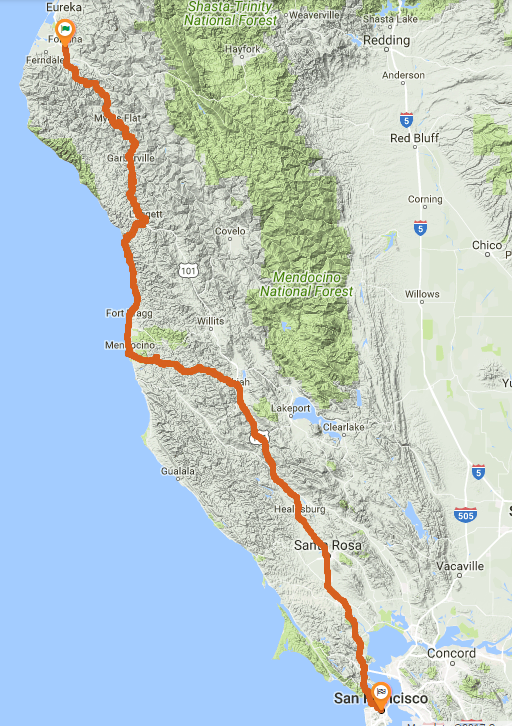
Farther on at Leggett we see a tourist duck pond and we buy Cracker Jacks and throw them to the ducks and he does this in the most unhappy way I have ever seen. Then we pass into some of the twisting coastal range road and suddenly enter heavy fog. Then the temperature drops and I know we’re back at the ocean again.
This is California 1 (CA-1) - the Pacific Coast Highway (PCH). It begins at Leggett. There is 22 miles of nice twisting road between Leggett and the coast.
When the fog lifts we can see the ocean from a high cliff, far out and so blue and so distant. As we ride I become colder, deep cold. We stop and I get out the jacket and put it on. I see Chris go very close to the edge of the cliff. It’s at least one hundred feet to the rocks below.
I take this to mean that they're actually on the coast, in conjunction with the ocean reference above.
Just coming to the coast on the PCH there are still cliffs, probably around 100 ft up as described.
You might catch glimpses of the ocean while inland, but not from a cliff.
So I take this to mean the cliffs right when the PCH first reaches the coast, it's our upper reference point along the coast.
There is a pulloff right where you hit the coast.
This is our last hard location reference for a while.
And it's not even perfectly solid, but we at least know exactly where the PCH hits the coast - right near Hardy, CA.
We'll call this POINT A (cliffs).
We’re on the Mendocino County coast now, and it’s all wild and beautiful and open here.
Mendocino County covers a large area, including both inland bookends Leggett and Ukiah. This location reference is of little help other than to confirm what we already knew.
Where the road drops down from the high cliffs to the beach we stop to rest. The ocean smell of rotting organic matter is heavy here and the cold wind doesn’t allow much rest. But I find a large cluster of grey rocks where the wind is still and the heat of the sun can still be felt and enjoyed. I concentrate on the warmth of the sunlight and am grateful for what little there is.
The northernmost "beach" on the PCH is the Westport-Union Landing State Beach, which is only about a mile south of the cliffs discussed above. There is an actual rest area here. Two stops in this short amount of time are quite possible and realistic however, it's a beautiful area with changing scenery.
A long time later we come to a town where a luminous haze which has seemed so natural over the ocean is now seen in the streets of the town, giving them a certain aura, a hazy sunny radiance that makes everything look nostalgic, as if remembered from years before. We stop in a crowded restaurant and find the last remaining empty table by a window overlooking the radiant street.
Fort Bragg is the best candidate I can figure for this town. It's the "long time later" part that's hard to sort out. The whole coastal travel distance isn't very far, and a lot happens here. We're leading up to the climax of the book at this point. We have a southern boundary before we head inland, but we need to be "a long time later" from the beach rest stop. Fort Bragg is about 18 miles / 30 minutes, and is also the largest town in the area, likely to have a busy restaurant.
I look for a bench somewhere in the luminous haze but there is none. Instead we climb on the cycle and go slowly south looking for a restful place to pull off. The road leads out to the ocean again where it climbs to a high point that apparently juts out into the ocean but now is surrounded by banks of fog. For a moment I see a distant break in the fog where some people rest in the sand, but soon the fog rolls in and the people are obscured. The fog opens for a moment, revealing the cliff we are on, then closes again, and a sense of inevitability about what is happening comes over me.
This is the climax of the book.
There are no hard reference points given.
It's suggested there are no benches, and later there are references to Chris sitting on the ground, a truck driving by, and nearby cliffs.
It's hard to pin down this location as it's likely not a rest stop, just somewhere they pulled over.
Based on context above and below, it's between Fort Bragg and Mendocino (the town, not county).
There's no obvious "high point" that "juts out into the ocean" in this area, but there are two possibilities that seem a close match.
Heeser Dr in Mendocino Headlands State Park, and Point Cabrillo area.
I think Heeser Dr, in modern times at least, is the closest geographic match, and is immediately north of the turn inland toward Ukiah.
There are no benches. Lansing Street is an obvious turn off of the PCH toward the coast - "The road leads out to the ocean again".
Heeser Dr looks like a "restful place to pull off".
Chapter 32
As we ride now through coastal manzanita and waxen-leafed shrubs, Chris’s expression comes to mind. “I knew it,” he said. The cycle swings into each curve effortlessly, banking so that our weight is always down through the machine no matter what its angle is with the ground. The way is full of flowers and surprise views, tight turns one after another so that the whole world rolls and pirouettes and rises and falls away.
We're post-climax, the tension with the author and Chris is resolved. This paragraph offers little assistance in locating them. The reference to riding through the shrubs suggests they have began to head inland, which is confirmed in the next location reference.
Rich air and strange perfumes from the flowers of the trees and shrubs enshroud us. Inland now the chill is gone and the heat is upon us again. It soaks through my jacket and clothes and dries out the dampness inside.
Now we know they're moving inland, and the next hard reference is the town of Ukiah.
The southernmost way to get inland to Ukiah without back-tracking north is to take Comptche-Ukiah Road, which turns off just south of Mendocino and heads to Comptche.
I'm using this intersection of the PCH and Comptche-Ukiah Rd as the hard southern point on the coast - we'll call it POINT B.
From POINT A where we entered the coast on the cliffs to POINT B here, we're only about 31 or 32 miles south.
A lot happens in that 32 mile distance - multiple rest stops, "a long time later", lunch, and the climax of the book.
There is one more option further south to head back inland to Ukiah, but it is definitely back-tracking north a bit and doesn't follow the story.
I being to feel drowsy and in a small ravine ahead I see a turnoff and a picnic table. When we get to it I cut the engine and stop.
Another rest stop at an actual turnoff. There appears to be a number of turnoffs in this section of road, though none with a picnic table stand out. Heading inland, but not yet to Ukiah.
The road continues to twist and wind through the trees. It upswings around hairpins and glides into new scenes one after another around and through brush and then out into open spaces where we can see canyons stretch away below. The sunlight makes strange and beautiful designs through the tree branches on the road. It flits light and dark into my eyes. We swing into a curve and then up into the open sunlight. We head into a grove again,
Lovely descriptions, but nothing helpful.
And so we ride on and on, down through Ukiah, and Hopland, and Cloverdale, down into the wine country. The freeway miles seem so easy now. We pass through Asti and Santa Rosa, and Petaluma and Novato, on the freeway that grows wider and fuller now, swelling with cars and trucks and buses full of people, and soon by the road are houses and boats and the water of the Bay.
Ukiah here is our first hard location reference since Leggett, the last time we were inland.
The entire trip along the actual coast is void of hard references.
But here is a pretty strong indication that they're simply taking the 101 South at this point.
Just connect the dots of the towns with a freeway and there's only one option.
We have arrived at the end of the book.
We know San Francisco is the destination for the day, but we don't know where.
In an interview years later, Pirsig indicated the real destination of his trip was to Los Angeles,
and that they actually continued down California Rt 1 (the PCH) to Hollywood.