DAY 3 - Wednesday, July 10, 1968

Chapter 6
MY WATCH SAYS NINE O'CLOCK. AND IT'S ALREADY TOO HOT to sleep.
Unlike yesterday, late start here. They must've been tired from yesterday.
we get a fire started while Sylvia opens up packages of bacon and eggs and bread for breakfast.
Breakfast at camp, probably 9:30 or 10am by now.
I see we are at the left turn onto US 12 and John has pulled up for gas. I pull up beside him.
The thermometer by the door of the station reads 92 degrees.
When the tanks are filled we head across the street into a restaurant for coffee. Chris, of course, is hungry.
Coffee shortly after breakfast. But this reference must be somewhat embellished. Returning to US 12 to the north from the campground makes sense (i.e. Hwy 73 North), but their exact path is unknown. However, now about 5 decades later, there is no gas station at any of the left turns from the south onto US 12. It doesn't appear there ever was (there's not even any development at the intersection of 73 & 12). It's possible / likely they just returned the way they came, back to Lemmon, especially given the restaurant they stop at next. But this specific description cannot be taken literally.
This US 12 is old, bad highway. The broken concrete is tar-patched and bumpy. Road signs indicate detours ahead.
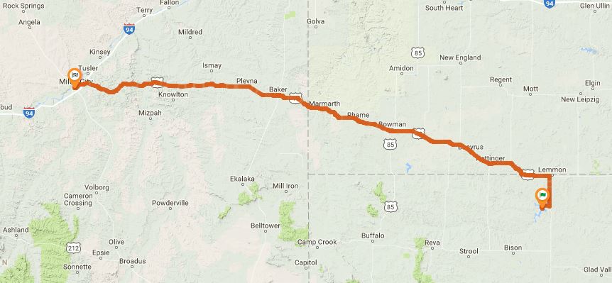
This confirms a pretty simple path today, basically following US-12. He never mentions following any detours though.
Chapter 7
On the horizon appears an image of buildings, shimmering slightly. I look down at the map and figure it must be Bowman.
In the restaurant I try to comment on this but no one is interested.
We pass through a town called Marmarth but John doesn't stop even for a rest and so we go on.
The descriptions here are pretty clean and include each town name, and it appears they stay on US 12 all the way to Miles City. This restaurant in Bowman would only be about two hours into the day's trip, seems a bit early for lunch, but possible since they got a late start.
At Baker, where we stop, the thermometers are reading 108 degrees in the shade. "We just want to get there fast," John says, and they both walk toward a restaurant. John and Sylvia don't say much, and John finishes his Coke early and is off to a bar for a snort.
They stop a few times but don't mention if it's just a drink break or for lunch.
We enter a low-rimmed canyon. Before long, a roadside stop I've been waiting for appears. A few benches, a little building and some tiny green trees with hoses running to their bases. John goes into the building to soak his shirt with water. I check the oil level.
This is after Baker, but before Miles City. Otherwise no way to pin down this rest stop. The low rimmed canyon could be near Cox Creek, best guess.
The road through the canyon doesn't straighten out into more of what we've been through, as I expected it would, but starts to wind upward. We reach the top of the climb dry again but cool now and stop, overlooking a huge valley and river below.
This is the last location reference of they day, but tomorrow he confirms they stayed at a hotel in Miles City, MT. The river valley is most likely the Powder River, east of Miles City. It's a shallow valley, but you can see for miles across it.
...Continue to Day 4