DAY 14 - Sunday, July 21, 1968
Chapter 26
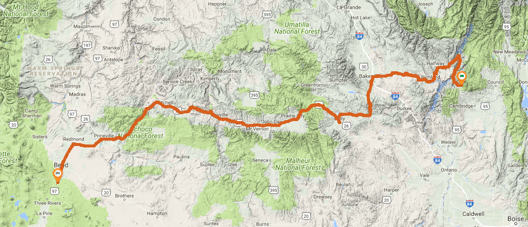
Soon we’re on the road again, which twists and turns. We stem down into an enormous canyon with high white bluffs on either side. The wind freezes. The road comes into some sunlight which seems to warm me right through the jacket and sweater, but soon we ride into the shade of the canyon wall again where again the wind freezes. Farther on we cross a dam and leave the canyon into some high semidesert country. This is Oregon now.
This covers about the first dozen miles of the day leaving camp. They must cross at Brownlee Dam, though not directly named it's really the only reasonable option. The only other possibility is Oxbow Dam, but the road up the Idaho side to there is unpaved even in modern times.
Time Zone Change - crossing the Snake River into Oregon takes them into Pacific Time.
The map before me says the town of Baker is soon ahead.
It's "Baker City" in modern times. In 1911 the city dropped "City" from its name, but restored it in 1989.
From Baker the cycle has taken us up through forests.
As we move again down the side of the mountain we see the trees thin out even more until we are in desert again.
We’ve come into the sage and sand of the desert and the engine’s started to sputter.
I switch to the reserve gas tank and study the map.
We fill up at a town called Unity and down the hot black road, through the sagebrush we go.
The town of Unity isn't quite directly on the route, but it's only a couple miles out of the way. Obviously they needed fuel and would have taken the slight side trip to get gas.
At Prairie City we’re out of the mountain forests again and into a dry-land town with a wide main street that looks right down through the center of the town and onto the prairie beyond it. We try one restaurant, but it’s closed. We go across the broad street and try another. The door’s open, we sit down and order malted milks.
This must be the lunch stop, they're about 4 hours into the day.
We’re pulling into Dayville and my rear end feels like it’s turned to concrete. Dayville has huge shade trees by the filling station where we wait for the attendant to appear. I ask him if there’s a place to rest and he says, “You can use my front lawn.”
Fuel / rest stop / nap here.
We stop for a long chocolate malted in the town of Mitchell, nestled in some dry hills that we can see out the plate-glass window. Dry desert, sandy country again. Into it we go. It’s late afternoon now and we’ve really covered the miles.
That's two malteds on the day. By Mitchell they've covered 260 miles on the longest day of 350+ miles. They really are putting down miles.
We arrive in Prineville Junction with only a few hours of daylight left. We’re at the intersection with Highway 97, where we’ll turn south, and I fill up the tank at the corner
There's a town called "Prineville, OR", but the intersection he's referring to where they turn south on US-97 occurs in Redmond, OR.
This is only a few miles west of Prineville.
However, there appears to be a separate, unincorporated community called "Prineville Junction" which is on the north side of Redmond.
We're in the right area, and I'm splitting hairs here, but his intersection reference didn't directly line up with the town name.
Because he references Prineville Junction and not Redmond, it could mean that he took the slightly northern route from Prineville on Hwy 370, rather than Hwy 126.
It appears on modern maps that Prineville Junction is referring to the railroad junction near Hwy 370, Yucca Ave, and US-97 on the northeast part of Redmond.
I can't find a gas station at ANY of the corners with US-97, so no help there.
Again I think Pirsig's "get gas at the corner" isn't meant to be taken literally.
At Bend we stop and have supper in a modern restaurant in which people also come and go without looking at each other.
Bend, OR is dinner and the camping spot for the night.
Farther south we find a forest of scrubby trees, subdivided into ridiculous little lots. Some developer’s scheme apparently. At one of the lots far off the main highway we spread out our sleeping bags and discover that the pine needles just barely cover what must be many feet of soft spongy dust.
This doesn't appear to be very far out of Bend, in fact they're within the city limits. Immediately south of Bend is Deschutes National Forest and all development stops.
Chris and I talk for a while about where we are and where we are going. I look at the map in the twilight, and then look at it some more with the flashlight. We’ve covered 325 miles today.
I put this number closer to 350 miles. If he's just estimating off of a map, it would be easy to not count all the details of winding roads. His estimate is within 10%. His odometer could also be off by 10% pretty easily as well.
Chapter 27
This entire chapter is a dream, they do no travelling.
...Continue to Day 15