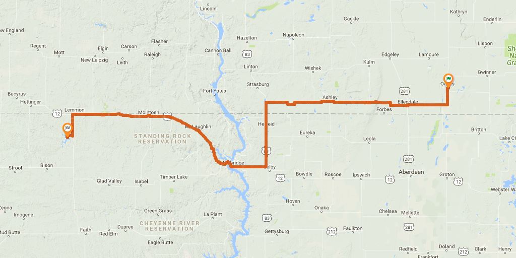
DAY 2 - Tuesday, July 9, 1968

Chapter 4
It ought to warm up as soon as the sun gets higher in the sky. About half an hour of this and we’ll be in Ellendale for breakfast. We should cover a lot of miles today on these straight roads.
The 1/2 hour to Ellendale again confirms last night's stop in Oakes, ND. The majority of this day's roads are very straight. Distance travelled this day is above average at about 274 miles.
If it weren’t so damn cold this would be just gorgeous riding.
Nobody’s even up yet, it looks like. My watch says six-thirty.
There it is! Ellendale!
The watch says seven-fifteen.
Very early start to the morning. Looks more like 45 minutes rather than 30 based on his watch. Oakes to Ellendale is about 31 miles, so again this makes sense at about 45 mph average speed.
Breakfast ends, and I say finally, “What next?” John says slowly and deliberately, “We’re not leaving here until it warms up.” A half hour later the thermometer by the hotel door reads 53 degrees.
A little chilly, could have been in the upper 40s on their early morning excursion. Which is a bit colder than the average low in the area for July.
Prairie. Tranquil and detached. Later, when we stop, Sylvia has tears in her eyes from the wind, and she stretches out her arms and says, “It’s so beautiful. It’s so empty.” I show Chris how to spread his jacket on the ground and use an extra shirt for a pillow. He is not at all sleepy but I tell him to lie down anyway, he’ll need the rest. I open up my own jacket to soak up more heat. John gets his camera out.
This is just a random stop, not possible to nail down a location. Assuming about halfway between Ellendale and Hague, they could be near the town of Ashley, ND. Lake Hoskins looks like a nice place to stop.
Chapter 5
We stop for gas at Hague and ask if there is any way to get across the Missouri between Bismarck and Mobridge. The attendant doesn’t know of any. The motorcycle gets a change of oil and chain lubrication. All of us go in a shop for coffee and rolls.
Fairly clear descriptions here. Hague is just before they turn south. Oil change and snack break here, 2nd of the morning after breakfast.
We decide to head south to Mobridge and cross there. The road south is awful. Choppy, narrow, bumpy concrete with a bad head wind, going into the sun and big semis going the other way.
There seems to be a nicer, windy alternate route (following 10 over Lake Pocasse), but by this description it appears they just turn south and stay on US-83.
At Herreid John disappears for a drink while Sylvia and Chris and I find some shade in a park and try to rest.
Confirmed they stay on US-83 South. They're taking a lot of breaks this morning. 3rd one since breakfast, haven't had lunch yet.
We have lunch of hamburgers and malteds at an A & W place in Mobridge, cruise down a heavily trafficked main street and then there it is, at the bottom of the hill, the Missouri.
Finally, lunch. 160 miles on the day at this point. Burgers and malteds sounds good.
We coast down the hill, clunk onto the bridge and across we go, watching the river through the girders moving by rhythmically, and then we are on the other side. We climb a long, long hill into another kind of country. Reservation Land.
Just a description of a terrain change over the river.
Time Zone Change - crossing the Missouri River takes them into Mountain Time.
At one stretch in the long desolate road we see an isolated grocery store. Inside, in back, we find a place to sit on some packing cases and drink canned beer.
Some have placed this in Watauga, SD. The grocery store is closed but now there is "Brenda's Cafe" there as of 2017. There is no way from the information in the book to confirm or deny this location, but the location and description seem close enough.
By the time we reach Lemmon we are really aching tired. At a bar we hear about a campground to the south. But we drag ourselves through a supermarket, pick up whatever groceries come to mind and with some difficulty pack them onto the cycles.
Campground to the south of Lemmon is at Shadehill Reservoir. Groceries purchased here are to become dinner tonight and breakfast on Day 3.
We drive down a county road from Lemmon, exhausted, for what seems a long, long time, but can’t be too long because the sun is still above the horizon. The campsite is deserted. Good. But there is less than a half-hour of sun and no energy left.
Camp is probably deserted because it's a Tuesday. They arrive late after a long day and many stops.
It is semidesert here, everything burned up and dry except for a lake, a large reservoir of some sort below us.
This confirms Shadehill Reservoir. There is another campsite in the area but it's not on the reservoir.
BANG! There’s a loud explosion behind us. Then I hear Chris giggling. Sylvia is upset. “I found some firecrackers,” Chris says.
We already know the trip began on a Monday in July of 1968, but it's this reference that tells us it's probably July 8, 1968 - the first Monday after the Fourth of July holiday. Assuming the firecrackers were recently leftover, and not ruined by time / heat / rain, and not left behind ahead of the holiday.
...Continue to Day 3